 overview & history cost & benefits development issues rails with trails canal towpath trails design of trails resources |
 |

|
|

|
The
detailed design of a shared use path or trail must consider all factors
that affect the safety, convenience and comfort of users. Railroad corridors
are typically quite straight and have gentle grades: two excellent qualities
for a bicycling and walking trail. Publications such as the AASHTO
Guide for the Development of Bicycle Facilities has extensive information on many
of the issues that are highlighted below. Some states also have developed
their own guidelines and manuals for trail design which match or exceed
recommendations in these national publications. For example, Iowa DOT
has included design and maintenance information in its statewide
trails planning document and both Oregon
and Florida
DOT's have extensive trail development sections in their design manuals.

Width
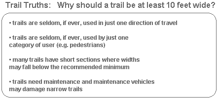
Shared use paths (or trails) should be a minimum
of 10 feet wide to accommodate multiple users traveling in both directions. Trails in urban areas are likely to require at least 12 feet of width and those with heavy use, or large numbers of in-line skaters, may need to go to 14 feet or wider. In rare circumstances (e.g. very rural areas and/or trails with no walkers or joggers) trails may be reduced to eight feet.
In addition to the width of the surfaced portion of the trail, two feet of clear space (like a shoulder) is recommended either side of the trail so that users can avoid signs, shrubs, walls, etc. The total width of the trail and clear space should be maintained through any tunnels, underpasses, bridges or overpasses.
Width
Shared use paths (or trails) should be a minimum
of 10 feet wide to accommodate multiple users traveling in both directions. Trails in urban areas are likely to require at least 12 feet of width and those with heavy use, or large numbers of in-line skaters, may need to go to 14 feet or wider. In rare circumstances (e.g. very rural areas and/or trails with no walkers or joggers) trails may be reduced to eight feet.
In addition to the width of the surfaced portion of the trail, two feet of clear space (like a shoulder) is recommended either side of the trail so that users can avoid signs, shrubs, walls, etc. The total width of the trail and clear space should be maintained through any tunnels, underpasses, bridges or overpasses.
 |
Surface
The trail
experience is greatly affected by the choice of surface. Urban trails
usually have asphalt or concrete surfaces to withstand heavy trail use
and the impact of maintenance vehicles. Hard or sealed surfaces such as
these also provide in-line skaters with a place to skate. However, the
initial cost of an asphalt or concrete surface will often be significantly
more expensive ($125,000 per mile) than a soft or unpaved surface ($40-$50,000
per mile). Paved trails will also likely raise the speed of bicyclists,
which may be an issue in areas with heavy pedestrian use.
Rural trails are more likely to be surfaced with crushed limestone as this is usually cheaper and quicker, and is adequate for moderate or low use facilities. However, soft surface trails are not usable by in-line skaters and are more prone to flood or water damage. Some hard surface trails have a soft shoulder that is designed for joggers to use, and in areas with equestrian use, a parallel soft surface trail is recommended where space permits.
Alignment
The most popular and successful trails manage to remain direct without being boring; they avoid sudden or sharp turns and don't meander unnecessarily, and yet they are not completely straight either. The AASHTO guide provides detailed information or horizontal alignment, curve radii and other design elements affecting trail alignment. Trail design should take into account all the basic engineering principles that go into good roadway design. The alignment of a trail must maintain good sightlines for all users and allow cyclists to see, react and stop in time to avoid any potential dangers. We don't build highways with blind corners and curves that cars can't take without going up on two wheels -- neither should we design trails where bicyclists can't stop in time or can't make a corner.
Grade
Slopes greater than five percent are undesirable as many bicyclists have trouble climbing this steep of a slope. When traveling down a slope greater than five percent, some bicyclists may exceed the speeds at which they are comfortable or in control. Where terrain dictates, however, slopes may exceed five percent. The AASHTO Guide provides information on grade restrictions and grade lengths (e.g. a ten percent slope is recommended for lengths of only 100 feet), and also on a range of options that can be used to mitigate excessive grades such as signing, added trail width, longer sight lines, and even a series of switchbacks.
Structures
Many rail-trails
take advantage of bridges and tunnels that were built to accommodate
trains, and are therefore strong enough to support bicycle and pedestrian
use. However, some bridges have to be replaced or restored. Other trails
must span highways, rivers and creeks, and other natural and man-made
barriers with new crossings. The AASHTO Guide recommends
Intersections
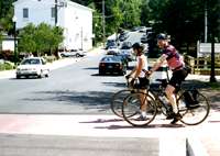
Intersections between paths and roadways are often the most critical issue in shared use path design and require considerable care. Although every intersection is a little different from the next, the AASHTO Guide identifies three basic categories of path-roadway intersection:
The Guide goes on to discuss design issues related to stopping distances, traffic signals, refuge islands and many other factors. Some of the basic principles to apply include:
|
Rural trails are more likely to be surfaced with crushed limestone as this is usually cheaper and quicker, and is adequate for moderate or low use facilities. However, soft surface trails are not usable by in-line skaters and are more prone to flood or water damage. Some hard surface trails have a soft shoulder that is designed for joggers to use, and in areas with equestrian use, a parallel soft surface trail is recommended where space permits.
Alignment
The most popular and successful trails manage to remain direct without being boring; they avoid sudden or sharp turns and don't meander unnecessarily, and yet they are not completely straight either. The AASHTO guide provides detailed information or horizontal alignment, curve radii and other design elements affecting trail alignment. Trail design should take into account all the basic engineering principles that go into good roadway design. The alignment of a trail must maintain good sightlines for all users and allow cyclists to see, react and stop in time to avoid any potential dangers. We don't build highways with blind corners and curves that cars can't take without going up on two wheels -- neither should we design trails where bicyclists can't stop in time or can't make a corner.
Grade
Slopes greater than five percent are undesirable as many bicyclists have trouble climbing this steep of a slope. When traveling down a slope greater than five percent, some bicyclists may exceed the speeds at which they are comfortable or in control. Where terrain dictates, however, slopes may exceed five percent. The AASHTO Guide provides information on grade restrictions and grade lengths (e.g. a ten percent slope is recommended for lengths of only 100 feet), and also on a range of options that can be used to mitigate excessive grades such as signing, added trail width, longer sight lines, and even a series of switchbacks.
Structures
|
-
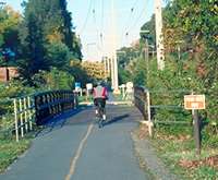
� The clear width should be the same as the trail width PLUS the 2 feet
of clear space on either side; this provides clearance from tunnel walls
or bridge railings and allows clearance from users who may have stopped
on the bridge.
� Railings, fences or barriers should be a minimum of 42 inches high.
� Bridges should be designed for pedestrian live loadings and maintenance vehicles.
|
Intersections between paths and roadways are often the most critical issue in shared use path design and require considerable care. Although every intersection is a little different from the next, the AASHTO Guide identifies three basic categories of path-roadway intersection:
� midblock crossings: where the trail crosses a highway away from existing intersections
� adjacent path: where the trail crosses a highway at an existing intersection
� complex: where other configurations exist
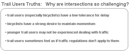
The Guide goes on to discuss design issues related to stopping distances, traffic signals, refuge islands and many other factors. Some of the basic principles to apply include:
-
� Try to ensure trails cross roadways at an angle of 90 degrees, or
as close to that as possible, even if this means slightly realigning
the trail or roadway.
� Treat intersections consistently so that users can readily identify them as they are approaching.
� Use sound engineering judgement and follow the Manual on Uniform Traffic Control Devices (MUTCD) to determine the type of traffic control device to use.
� Make trail users visible and their movements as predictable as possible.
 |
Roadway
Separation
The AASHTO Guide strongly recommends against the development of trails that are immediately adjacent to roadways. This type of facility, that is often little more than a wide sidewalk, encourages wrong-way riding (a leading cause of bicycle-motor vehicle crashes) and makes trail users much less visible to motorists at intersections. Sidewalk trails can also set up conflicts at every driveway or intersection along a roadway.
However, a rail corridor running adjacent to a highway may not suffer from as many negatives as there are likely to be fewer intersections to negotiate and there already may be greater separation between the trail and roadway. The minimum amount of separation recommended is
The AASHTO Guide strongly recommends against the development of trails that are immediately adjacent to roadways. This type of facility, that is often little more than a wide sidewalk, encourages wrong-way riding (a leading cause of bicycle-motor vehicle crashes) and makes trail users much less visible to motorists at intersections. Sidewalk trails can also set up conflicts at every driveway or intersection along a roadway.
However, a rail corridor running adjacent to a highway may not suffer from as many negatives as there are likely to be fewer intersections to negotiate and there already may be greater separation between the trail and roadway. The minimum amount of separation recommended is
-
� five feet of horizontal separation, or
� forty-two inches of vertical separation (provided by a barrier or railing)